DESIRABLE TERRITORIAL CHANGES ALONG AND BEYOND THE LINE OF CONTROL IN JAMMU AND KASHMIR
History provides no example of a cease-fire line that has been transformed into a viable international boundary. Rather, such inherently unstable lines serve as grim reminders of enmity between neighbors and of reliance on warfare, in place of reason, in dealing with international disputes. Fortunately, rational alternatives do exist. In what follows and in the accompanying map we present what we believe to be an optimal set of territorial changes between India / Eastern Kashmir and Pakistan / Western Kashmir.
| Précis of Recommended Territorial Exchanges | |
| Indian-held Tracts to Go to Pakistan and Western Kashmir | Pakistani-held Tracts to Go to India and Eastern Kashmir |
| Total area: 1,738 sq. mi. (4,501 sq. km.) | Total area: 2,844 sq. mi. (7,366 sq. km.) |
| Total population (2000 est.): 595,000 | Total population (2000 est.): 150,000 |
| Total area of all tracts to be exchanged: | |
| 4,562 sq. mi. (11,815 sq. km.), 5.3% of total pre-independence area of state. | |
| Total population of all exchanged tracts: | |
| 745,000, 5.5% of estimated population of the state in the year 2000. | |
Figure 8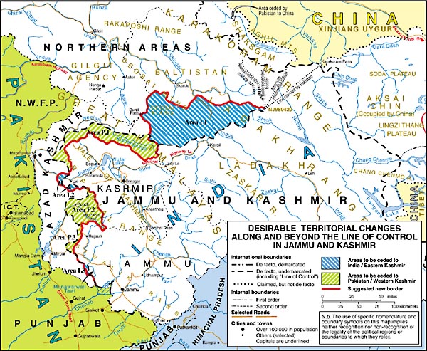
Rationale
Overall, the territorial adjustments should not be excessively disruptive of the established order and yet should appear significant and be of such a nature as to allow all parties to claim a victory. The awards would secure for Pakistan and Western Kashmir control over the whole of two presently divided river basins, the Neelam / Kishenganga (map area P.1) and the Punch (map area P.2) that are important for proper watershed management and development. Of the two, the well-forested Punch watershed is especially important in respect to the future of the country's vital Mangla Dam and reservoir. The changes envisaged would be wholly consistent with the Indus Waters Treaty of 1960 and would, in fact, facilitate the fair division of waters within the Indus drainage basin, for which the Treaty provides.
In India's and Eastern Kashmir's case the awards would enhance security in two significant respects. First, it would provide a protective apron of territory (map area I.1) to the north of national highway 1A, especially in the vicinity of Kargil. It would also widen the territorial buffer protecting the major, newly constructed Uri hydroelectric facility (map area I.2). In general and wherever feasible, the suggested new boundary would follow crests to help reduce the likelihood of hostile military confrontations. It would also be prudent to establish a demilitarized band of territory with a width of 10 kilometers (6.2 miles) on each side of the new line to further diminish the likelihood of cross-border incidents. Joint Indo-Pakistani patrols of the demilitarized band would then be in order.
Finally, the unfinished border beyond the present terminus of the LOC (at grid point NJ 980420) should be extended to the border with China. The existence of this gap has led to protracted Indo-Pakistani conflict in the Siachen Glacier area. Since the intervening terrain is mountainous, barren, devoid of permanent habitation, and of little, if any, military value, the simplest border that could be drawn here would be an arc of a great circle, either due north to the de facto border with China or, alternatively, to the eastern extremity of the Shaksgam Tract, which Pakistan ceded to China in 1963. The latter solution would have the distinct advantage of precluding the possibility of future conflict between India and China in respect to this sector of their still-disputed international border. The provisions for a demilitarized band of territory noted in the previous paragraph should also be made applicable to the extension of the border in the north.
Selected sites along the newly established border should be designated as transit points for free transportation and trade between the populations on either side of the line.