A HYPOTHETICAL KASHMIRI STATE
OR STATES
With No Territorial Exchanges between India and Pakistan, Versions A and B
Figure 6 illustrates two
possible dispensations in regard to Kashmir. The first (Version A)
envisages two hypothetical Kashmiri states that might emerge assuming
the concurrence of both India and Pakistan in the establishment on
either side of the present Line of Control of sovereign entities that
would be self-governing in all essential respects, but without an
international personality, as described in the 1998 Livingston proposal,
"Kashmir - A Way Forward." An alternative to this arrangement
(Version B) would be the establishment – again with the concurrence
of India and Pakistan — of a single Kashmiri state straddling
the present Line of Control.
Figure 6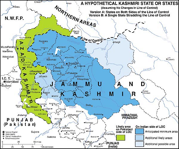
Various routes to the establishment of the states envisaged in Version A are feasible. But, whatever route may be chosen, it should involve some means of ascertaining and, within reason, following the desires of local populations in respect to how the states shall be constituted and whether or not specific areas are to be included within them. There is abundant reason to suppose – on cultural, linguistic, and religious grounds – that a clear majority of the people in many areas that were included in the erstwhile princely state of Jammu and Kashmir would not wish to be incorporated in either of the two hypothetical states under discussion. These areas are left white on our map. (For relevant evidence see figure 4 and figure 5.) It is no less apparent that a clear majority of the people of Kashmir proper would welcome the opportunity to live in a hypothetical sovereign Kashmiri state. Between these two extremes are a number of problematic areas.
In preparing figure 6, we have assumed no attendant territorial exchanges between India / East Kashmir and Pakistan / West Kashmir. Further, we assumed that the administrative units for ascertaining the wishes of the people will be tahsils, in that many districts are so culturally heterogeneous that any decision taken for the district as a whole would be viewed unfavorably by significant minorities.
On the Indian side of the LOC, we judge that every tahsil in Kashmir proper and in Doda district in Jammu, and Gool Gulab Garh tahsil in Udhampur district in Jammu would seek incorporation in the proposed state. All these areas (colored deep blue on our map) are imbued with "Kashmiriyat" (the cultural traditions of the Vale of Kashmir) and/or interact extensively and beneficially with Kashmiri-speaking people. In all but five of the tahsils so designated, Kashmiri is the language of a clear majority of the population, while in three of these five problematic tahsils, Kashmiri is the single leading language, accounting for more than 40% of the total population. The anticipated minimum area of the state had a population in 1981 of 3.68 million people.
Adjoining the foregoing area are the mountainous district of Punch and three northern tahsils of the adjacent district of Rajauri (mapped in medium blue) whose populations are mainly speakers of Gojri and Pahari. This predominantly Muslim tract has had close ties with Kashmir over many centuries and would likely opt for inclusion in a Kashmiri state if given the choice. Its population in 1981 was 0.41 million. To the east of Kashmir proper lies the culturally distinctive tahsil of Kargil in the district of the same name (light blue on map), a predominantly Muslim area whose principal language, Balti, is a dialect of Tibetan. Though this group too has long interacted closely with Kashmiris, their desire to join a Kashmiri state cannot be assumed. The 1981 population of this large tahsil was a mere 58 thousand.
If all the areas discussed to this point were to opt for inclusion in an Eastern Kashmiri state, their combined population in 1981 would have been 4.15 million. Today (2000), it might be on the order of 6.6 million.
On the Pakistani side of the LOC, it is conceivable that the whole of what is now Azad Kashmir would opt to have a sovereign status more or less equivalent to that of the Eastern Kashmiri state. This predominantly Punjabi-speaking, wholly Muslim area does have a fairly high degree of cultural homogeneity, but some portions of the state are more closely integrated than others to Pakistan. It is presently difficult to gauge the wishes of the people of the region and we have, therefore, not attempted to distinguish varying regional degrees of desire for a new political dispensation. The region's population in 1981 was 1.98 million. Today it may be estimated as approximately 3.2 million.
In the proposal designated as Version B, the sovereign Kashmiri entity would, at a maximum, comprise all of the areas shown in green and in various shades of blue on figure 6. At a minimum, it would probably include the whole of the area shown in dark blue and a significant portion of the area shown in green. The arguments noted above relative to the desire of specific areas to be a part of a sovereign Kashmiri entity would presumably apply to Version B (were it to be countenanced) as well as to Version A. While the problem of formulating a viable constitution for this hypothetical single Kashmiri state would, obviously, be more difficult than for the two hypothetical states in Version A, precedents for such an arrangement do exist.