A HYPOTHETICAL KASHMIRI STATE
With Territorial Exchanges between India and Pakistan, Version F
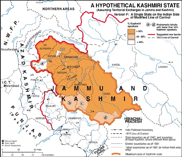
Our considerations in making the following map are the same as for figure 7, except for the assumption here that India and Pakistan will agree to territorial exchanges along the lines suggested in our map entitled "Desirable Territorial Changes Along and Beyond the Line of Control in Jammu and Kashmir" (figure 8). In this case, there would be only four, rather than the previously noted five, problematic tahsils where Kashmiri is not the majority language. The small tahsil of Karnah will have been transferred to Pakistani control along with other areas to the north and west of the divide between the Neelam / Kishenganga and upper Jhelum drainage basins. The remaining tahsils, a-d on this map, correspond to those identified by the letters b-e on figure 7; and the comments made in respect to them in the text for that map are also applicable here.
In that the population of the area that would hypothetically be ceded to Pakistan has a substantial, if not a majority, population of non-Kashmiri speakers, the net effect of the territorial exchanges in both directions would result in a somewhat higher proportion of Kashmiris in the total population of the potential new Kashmiri state than the figures indicated in the text for figure 7 (namely 90.1% for the minimum area and 84.4% for the maximum area). There would also be a slight net loss in the state's total population. Using 1981 figures, it would go down by nearly 100,000 from the 3.28 million reported for the state's minimum area or 3.68 million for its maximum area. The minimum and maximum for the present day would likely be somewhat over 5.1 million and 5.7 million respectively.
The relatively high degree of cultural homogeneity that would characterize the state depicted on this map would be among the strongest arguments in its favor.
Figure 10